
Geothermal Paradise Under Threat: Grindavik and Blue Lagoon Evacuated Amid Earthquake Swarm
Seismic Activity Prompts Precautionary Measures in Iceland's Reykjanes Peninsula
Grindavik, a coastal town on Iceland's Reykjanes Peninsula, and the world-renowned Blue Lagoon geothermal spa have been evacuated following a surge in earthquake activity. The decision, made by local authorities and Blue Lagoon management respectively, aims to prioritize the safety of residents and visitors in light of the escalating seismic events.
Unprecedented Earthquake Activity Raises Concerns
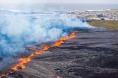
The Reykjanes Peninsula, known for its volcanic and geothermal activity, has experienced a significant increase in earthquake frequency and intensity in recent days. Experts at the Icelandic Meteorological Office (IMO) are closely monitoring the situation, noting a concerning pattern of ground deformation that suggests potential magma movement beneath the surface. The concern is not just the earthquakes themselves, but the possibility of a volcanic eruption, although the likelihood and location remain uncertain.
Evacuation Details: Prioritizing Public Safety
The evacuation of Grindavik, a town of approximately 3,000 residents, began promptly after the alert was issued. Emergency services, along with volunteers, assisted in the safe and orderly departure of residents to designated evacuation centers in nearby towns. The Blue Lagoon, a major tourist attraction, also implemented its evacuation protocols, ensuring the departure of all guests and staff. The evacuation process was reported to be smooth and coordinated.
Expert Analysis: Assessing the Volcanic Risk
Geologists and volcanologists are working diligently to assess the volcanic risk associated with the ongoing seismic activity. Preliminary data indicates that magma accumulation could be occurring at a relatively shallow depth, increasing the potential for a surface eruption. However, predicting the exact timing and location of a potential eruption remains a challenge.
Key areas of investigation include:
- Monitoring ground deformation using GPS and satellite imagery.
- Analyzing earthquake locations and magnitudes to identify potential magma pathways.
- Assessing gas emissions from fumaroles and geothermal areas.
- Modeling potential eruption scenarios to prepare for various outcomes.
The Blue Lagoon: Temporary Closure and Future Plans
The Blue Lagoon has announced a temporary closure until further notice. The company has emphasized that the safety of its guests and staff is its top priority. Management is actively monitoring the situation and collaborating with local authorities and geological experts to assess the risks and determine the appropriate time to reopen. Updates will be provided through the Blue Lagoon's official website and social media channels.
Community Support and Resources
The Icelandic government and various organizations are providing support to the evacuated residents of Grindavik. Resources include temporary housing, financial assistance, and counseling services. The community is rallying together to provide aid and comfort to those affected by the evacuation. Information on available resources is being disseminated through local media outlets and community centers.
Looking Ahead: Uncertainties and Preparedness
The situation in the Reykjanes Peninsula remains dynamic and uncertain. While the immediate focus is on ensuring the safety and well-being of the affected communities, long-term planning is also underway. This includes developing contingency plans for various eruption scenarios, enhancing monitoring capabilities, and providing ongoing support to the evacuated residents. The events serve as a reminder of the powerful forces of nature that shape Iceland's unique landscape and the importance of preparedness in the face of geological hazards.
Iceland's History of Volcanic Activity
Iceland is a land forged by fire and ice, with a rich history of volcanic activity. The island nation sits atop the Mid-Atlantic Ridge, a major plate boundary where the North American and Eurasian tectonic plates are moving apart. This geological setting makes Iceland one of the most volcanically active regions in the world. Past eruptions have shaped the landscape and influenced the lives of its inhabitants. The current situation underscores the need for continuous monitoring and preparedness to mitigate the risks associated with volcanic activity.
Staying Informed
It is crucial for residents and visitors to stay informed about the latest developments. Official sources of information include:
- The Icelandic Meteorological Office (IMO): en.vedur.is
- The Department of Civil Protection and Emergency Management: www.almannavarnir.is/en
- Local news outlets
Updates will be provided as the situation evolves. The safety of the public remains the paramount concern.